User Overview

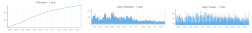
Followers and Following

Followers
Following
Trendsmap

History

Total Followers - Last Year
Daily Follower Change - Last Year
Daily Tweets - Last Year

Tweet Stats

Analysed 24,667 tweets, tweets from the last 299 weeks.
Tweets Day of Week (UTC)
Tweets Hour of Day (UTC)
Key:
Tweets
Retweets
Quotes
Replies
Tweets Day and Hour Heatmap (UTC)

Tweets

Last 50 tweets from @JimCantore
SNOWPACK: Latest numbers as of 5:12AM this morning put us DANGEROUSLY close to the record snowpack of 1983! Snow Water Equivalent (SWE) now at 25.7"! #utwx ❄️🏔️ pic.twitter.com/dXPlR3zsEa
Replying to @KSL_Matt
What should we watch for flooding here going forward into late spring besides the obvious, A quick warmup. Thanks in advance.
 
Jim Cantore Retweeted ·  
SNOWPACK: Latest numbers as of 5:12AM this morning put us DANGEROUSLY close to the record snowpack of 1983! Snow Water Equivalent (SWE) now at 25.7"! #utwx ❄️🏔️
 
Now that @NWSLosAngeles has officially rated the #MontebelloTornado an EF1 at 110mph, here's our 1st video report on the cell b4 it became tornadic, as it passed over the Southbay area & headed twrds East L.A., what a day for #weather in Socal...Erika's on it! #stormchaser #cawx pic.twitter.com/mUJPyj8IrI
Replying to @JayDobensky @NWSLosAngeles and 9 others
I knew you'd be on it!!
 
Today at 955am CDT, SPC began issuing MCDs with new graphics. MCD 308, issued by meteorologist Aaron Gleason, supported by meteorologists & developers Nathan Wendt, Chris Karstens & Jay Liang marks months of work to bring updated & more modern graphics to the MCD product. pic.twitter.com/FIi0i9PHJI
Replying to @NWSSPC
Looks good guys!
 
Yesterday’s tornado in Montebello, California was rated by @NWSLosAngeles as an EF-1 with winds of 110mph! This is the strongest tornado to impact the Los Angeles metro in 40 years! (March of 1983). #CAwx

@JimCantore @StephanieAbrams @spann pic.twitter.com/gj9sqEdjj2
Replying to @CollinGrossWx @NWSLosAngeles and 2 others
no actually you aree correct that is the final. apologies i was reading an old email.
 
Yesterday’s tornado in Montebello, California was rated by @NWSLosAngeles as an EF-1 with winds of 110mph! This is the strongest tornado to impact the Los Angeles metro in 40 years! (March of 1983). #CAwx

@JimCantore @StephanieAbrams @spann pic.twitter.com/gj9sqEdjj2
Replying to @CollinGrossWx @NWSLosAngeles and 2 others
That's prelim. They are going out again.
 
In reply to @JimCantore
What’s the significance of this video? Just curious as I’ve never seen this before; is it abnormal to be this rough
 
In reply to @ggweather
If I recall correctly I think I certified at least 2 of them—one near solar plant close to Desert Center and one over I-10 west of Blythe. Very difficult to certify and rate them in those remote areas as mostly ef0 landspouts and often without good track damage documentation.
Replying to @wxphx @ggweather
Today looks like they have lot to look at. Sadly!
 
In reply to @JimCantore
you should chase friday jim 😳😳
Replying to @WxHunain
Jim's brother is in town
 
Latest @NWSWPC 72-Hour Probability of Snow Accumulating ≥ 4"
 
Here is what is looks like modeled out through Saturday morning. Fast winds and colder air aloft over a warmed and unstable airmass on Friday. Could see some strong tornadoes over the ArkLaMiss!!
GIF
 
The driver of the pending SEVERE/FLOOD threat is over CA/NV. Winds will be very fast at 20,000 feet AG. It won't take much to bring some of these down to the ground especially Friday and Friday night.
GIF
 
Friday/Friday night max out our SEVERE risk this week w/models depicting supercells in the warm sector transitioning into a line of storm overnight. Both modes feature a tornado and damaging wind risk as ramped up atmospherics put us in those threats. Latest SPC/WPC below:
 
Speaking of ramped up SEVERE... things will start lighting up along and north of a frontal boundary this afternoon and tonight with waves of elevated thunderstorms and heavy rain. Severe storms will pose a large HAIL threat in OK and north TX.
 
In reply to @JimCantore
At what point are we going to call it a hurricane?
 
 
It’s hard to believe in one year, if everything goes to plan, I’m going to be a meteorologist. Something I have dreamed of since I was four. Thanks for being inspirations of mine 🌩️@ReedTimmerAccu @JimCantore #wxtwitter twitter.com/i/web/status/1… pic.twitter.com/GYbSmXvabn
See you out there Josh!! :)
 
The Montebello, CA tornado yesterday stole the show. All this energy heading east for a much more widespread and active end to the weekend SEVERE wise in the south.
 
The day before the tornado in SF.
Just next to the Ferry Building in SF. #cawx pic.twitter.com/ym4IPJmT7D
 
Jim Cantore Retweeted ·  
Yes, California gets tornadoes! There have been 468 since 1950, an average of 6.4 per year, Los Angeles County has had the most with a total of 45 (not counting today), followed by adjacent and much smaller Orange County with 31!
 
Jim Cantore Retweeted ·  
In reply to @rawsalerts
🚨#UPDATE: Watch More incredible footage showing the extremely rare tornado touching down and doing serious damage to multiple buildings
 
Jim Cantore Retweeted ·  
In reply to @ABC7
I caught it one video.
 
Jim Cantore Retweeted ·  
#BREAKING Landspout rips off the roofs of buildings in Montebello, damages cars and utility lines, injures 1 person
abc7.com/weather/landsp…
Landspout rips off the roofs of buildings in Montebello, injures 1 person
abc7.com
 
Jim Cantore Retweeted ·  
Our famous "Boot Cam" has been buried over and over again, under nearly 60 FEET of snowfall this season. We've lost count of how many times we've dug him out this year.
 
Replying to @ChicagoMikeSD @JenCarfagno and 3 others
no sou'easter winds from the east southeast.
 
In reply to @JenCarfagno
technically the storm didn't bomb out... just one reporting site (buoy in Monterrey bay) ;)
Replying to @JenCarfagno @stormewarren and 2 others
Yeah starting to put that together.
 
In reply to @JimCantore
For us in Leesburg, VA - north of Lynchburg: Per @wunderground in Leesburg, the average temperature to date for March is 42.9. For February, we were 45.2 degrees. I assume the next 10 days will get us closer to that 45.2 average.
several areas in the southin same boat
 
Lynchburg, VA
It's like winter is mad and keeps storming out and then coming back in to yell "AND ANOTHER THING!!!!!"... but Spring will get the last laugh this week as temperatures bump into the upper 70s and low 80s REAL QUICK for tomorrow and Friday in Central Virginia. #VaWX pic.twitter.com/oABZMBQptX
 
 
Jim Cantore Retweeted ·  
#MontereyBay buoy today really took a dip.
Sea level pressure dropped 24 millabar in just under 17 hours! Yikes! That's a meteorological💣(24 mb or more drop in 24 hours or less). And we had the winds to prove it. That round up will be coming shortly.
#cawx
 
Jim Cantore Retweeted ·  
Arizona flooding getting real. This is in-between PHX and FLG
 
 
In reply to @JimCantore
GM Jim all clear out on the weather terrace this morning my friend how you doing
Replying to @Coffeebeansteve
copy that thank you. all good here.
 
As all that energy moves east expect SEVERE storms to fire. Even though all hazards are in play, Wednesday and Thursday feature a higher chance at damaging HAIL. Friday into FRIDAY NIGHT looks like the better chances of damaging wind and tornadoes.
 
Here is how we got those strong gusts and severe wind reports yesterday.
Last several hours of radar data out of San Francisco via @RadarOmega

Can't say I've seen two meso-lows Fujiwara off the California coast like this before. Numerous reports of wind damage have been coming in as these produced gusts of around 60 - 80 mph. #CAwx pic.twitter.com/FfJOCXdI2y
 
Now we just need Godzilla as icing on the cake. Lol @JimCantore
 
In reply to @JimCantore
Agreed! Good morning!
 
Pretty wild to see the only SEVERE reports from CA/NV
 
Jim Cantore Retweeted ·  
Unreal waves and wind in the San Francisco Bay today @KPIXtv @PaulKPIX
 
Jim Cantore Retweeted ·  
Lots of downed trees in the neighborhood, stay safe!
 
Jim Cantore Retweeted ·  
Traffic alert: The Third Street Bridge is shut to through traffic — historic span struck by barges during high winds and surf. Our engineers are on site assessing damage. twitter.com/i/web/status/1…
 
Jim Cantore Retweeted ·  
STRONG WINDS: My parents sent these photos of a large tree that fell in their neighborhood in Redwood City amid high winds and rainy conditions today. @KPIXtv
 
Jim Cantore Retweeted ·  
Welcome back: Tulare Lake has come back to life after many years in the Southern Central Valley. #CAwx #WxTwitter
 
 
Jim Cantore Retweeted ·  
California Hail Storm & Severe Weather Working It's Way Through Sacramento, California 3/21/2023
#thunderstorms #Hailstorm #windstorm #wxtwitter #CAwx #WX #CaliforniaWeather
 
Jim Cantore Retweeted ·  
** High winds downing trees & prompting power outages **
 
Wow! I’ll take “Unlikely Weather Events” for 1,000 Alec…..@JimCantore @JenCarfagno @weatherchannel @HenryRothenberg pic.twitter.com/uajF0Fj1eC
Replying to @stormewarren @JenCarfagno and 2 others
Lots of spin there yesterday
 
how can temperatures drop to 37 by midnight but the next day’s low temperature is 47?

wouldn’t the low temperature just be 37 the next day with the day starting off at 37?

@JimCantore you’re a weather guy
Replying to @EricWebler
Assuming didn’t drop 37 would be the low for 24hours. Midnight to midnight.
 
My son loves watching @weatherchannel with me first thing in the am while the other kids sleep. He calls it Mom’s weather show. pic.twitter.com/272VeXfntR
 
Jim Cantore Retweeted ·  
Check out this cool radar loop of two centers of low pressure dancing around one another as they draw closer to the coastline. This is known as the Fujiwhara Effect!

Heavy rain and wind will continue to impact California into tomorrow.

weather.us/radar-us/1222-…
MG
GIF
 
 
For access to this functionality a Trendsmap Explore subscription is required.

A Trendsmap Explore subscription provides full access to all available timeframes

Find out more

Thanks for trying our Trendsmap Pro demo.

For continued access, and to utliise the full functionality available, you'll need to subscribe to a Trendsmap Pro subscription.

Find out more

This account is already logged in to Trendsmap.
Your subscription allows access for one user. If you require access for more users, you can create additional subscriptions.
Please Contact us if you are interested in discussing discounts for 3+ users for your organisation, or have any other queries.